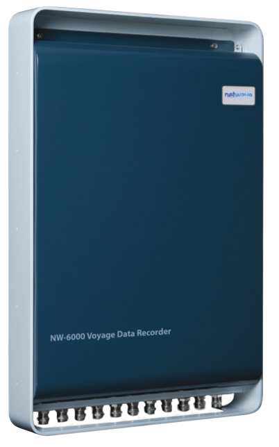
JLR-7500/7800

The JLR-7500/JLR-7800 (D)GPS navigator will locate your position accurately and gives you a wide range of possibilities. Integrated with the latest technologies. That will enhance your operational performance. Of the new display modes is the 3D highway, which allows you to intuitively view the location of the next waypoint. This 3D guidance is particularly valuable to follow a real-time chain of waypoints along a planned route. The new (D)GPS navigator allows you to plan long distance routes highly effective. It is possible to set Rhumb lines (RL) for short legs, while Great Circle (GC) can be set for the long distance legs. All possible within the same route. Simply make your selection for each leg to reach your destination effortlessly. All information is displayed on a highly visible 5.7-inch LCD display, featuring added sharpness and contrast compared to the previous version. Many display modes are readily available and selectable from the menu, such as navigation, CDI, highway, track plotting and service and information screens. The display has four dim modes, allowing adjusting at your own convenience.

2020-06-12T09:36:08-03:0022/04/2020|

JLR-7600/7900

The JLR-7600 GPS navigator will locate your position fast and with high accuracy, keeping the unit compact and easy to install. Up to 1,000 waypoints can be stored in the internal memory. All waypoints can be named and renamed up to sixteen characters. You can make 20 routes with 50 waypoints per route, which can be entered randomly, and there's room for 2,000 points for ships' track and up to 1,000 for events and marks. The JRC MID incorporates many display modes readily available on a highly visible 4.5-inch LCD display. Besides the display being fully dimmable and having backlit keys, it features dual LED backlight (white and orange), making it easy to operate in various light settings on the bridge. Multiple display modes are available from the menu with main data displayed in large characters for easy reading. You can easily switch at your own convenience, particularly useful when a situation requires specific information.

2020-06-12T09:39:19-03:0022/04/2020|

JLR-8400

The compact JLR-8400 GPS navigator is compatible with Multi GNSS and will provide accurate position data even in Arctic area, without SBAS and beacon. The newly designed multi-GNSS sensor is capable of receiving data from GPS as well as GLONASS, QZSS or BeiDou at the same time, allowing for a highly accurate positioning without beacon and SBAS. The sensor can increase the accuracy of your position by receiving SBAS correction data. The JLR-8400 is very compact and can virtually be mounted anywhere using the desktop flush mount system. The base of the sensor is designed for an easy installation, either on a pole or on a suitable bracket. The base also includes a slot allowing for easy cable management.

2020-06-11T20:12:21-03:0022/04/2020|

JLR-8600

The new JLR-8600 GPS navigator combined with our trusted 6.5-inch touch display will locate your position with high accuracy utilizing our newly designed antenna, providing you with the comfort of an intuitive operational approach. The newly designed multi-GNSS sensor is capable of receiving data from GPS as well as GLONASS or BeiDou at the same time, allowing for a highly accurate positioning, regardless of the weather conditions. The sensor can increase the accuracy of your position by receiving correction data SBAS satellites. The display is very compact and can virtually be mounted anywhere using our snap on flush mount system. The base of the sensor is designed for an easy installation, either on a pole or on an extension mast. The base also includes a slot allowing for easy cable management. Connecting everything together allows for a high reliability installation approach with redundancy of sensors, power supply and processor units.

2020-06-11T20:09:31-03:0022/04/2020|

JLR-21

The JLR-21 GPS compass continues the success of its predecessor, reaching a new level of performance and stability with many new features and enhancements. This system is also known as a 3D Dynamic Sensor™, which besides giving heading information, is designed to provide highly accurate information of the ships movement in all axis. The JLR-21 has heave functionality built-in as standard. In rough ocean conditions (with high waves), the GPS compass can correct up and down (attitude), movement. JLR-21 supports Speed Over Ground (SOG) and Course Over Ground (COG). The position, SOG and COG are updated every 200 milliseconds (which is 5 times faster than previous model JLR-20), delivering high accuracy.

2020-06-11T20:15:55-03:0022/04/2020|

JLR-31

The JLR-31 GPS compass continues the success of its predecessor, reaching a new level of performance and stability with many new features and enhancements. This system is also known as a 3D Dynamic Sensor™, which besides giving heading information, is designed to provide highly accurate information of the ships movement in all axis. The JLR-31 has heave functionality built-in as standard. In rough ocean conditions (with high waves), the GPS compass can correct up and down (attitude), movement. JLR-31 supports Speed Over Ground (SOG) and Course Over Ground (COG). The position, SOG and COG are updated every 200 milliseconds (which is 5 times faster than previous model JLR-20), delivering high accuracy.

2020-06-11T20:15:59-03:0022/04/2020|

JFC-130

JRC’s JFC-130 echo sounder incorporates a 10.4” high definition color LCD display. The innovative display modes allow you to select and view four kinds of 16 color gradations and background colors. Day and night mode is also available to support particular daytime operations. Keys and controls on the operation panel are minimized. Sensitivity, clutter rejection and STC are finely adjustable depending upon sea areas, seasons and fishing methods. Three types of fishing ground or fish species can be displayed and stored. Once they are on-screen, any type of fishing ground of fish species can be set and reset to another type by simply pushing the CUSTOM button. The adoption of a zero-line function, the new transducer makes the line finer. The high-speed emission of 600 (JFC-130) and 300 (JFC-130HP) pulses or more per minute enables small fish in the surface water to be clearly detected. The bottom enlargement display in 16 color gradations discriminates bottom fish from the sea bottom distinctly.

2020-06-12T12:07:36-03:0022/04/2020|

NW6000 Netwave

Netwave’s NW-6000 VDR system architecture is unique in the fact that the various components throughout the ship are interconnected by means of one single Ethernet cable, both Power and Data are provided over this very same single cable, eliminating the need for extensive and complex, and therefore costly, cabling requirements. Compared to other VDR systems, cabling costs are typically reduced by 50%! The standard VDR and (S)VDR systems consist of the following components: NetWave NW6000 Core Unit, NW6860-1000 Fixed capsule, NW-6680 Float free capsule, NW-6010 Bridge control Unit, NW-6020 PoE Microphones, and others.

2020-06-10T14:35:09-03:0022/04/2020|

JHS-183

The JHS-183 AIS is a ship borne system capable of regularly broadcasting own ship’s unique information and continually receiving and displaying information broadcast from other vessels. The AIS can "see around corners", allowing avoidance of dangers before visual contact has been established. All ship’s information including static and voyage related data such as the ship’s name and cargo, as well as its dynamic navigational information, i.e., position, course, and speed can be transmitted and received. The JHS-183 is an important piece of navigation equipment onboard for collision avoidance and maneuvering. The information broadcast from other ships displayed on the AIS, together with the geographical information shown on the radar or ECDIS provides highly important data for strategic decisions and for prompt contact with other ships. The JHS-183 is able to display up to 200 AIS targets and the excellent on-screen menus will greatly shorten most users' learning period.

2020-06-09T01:08:10-03:0022/04/2020|

A200

The em-trak A200 AIS Class A sets new standards of performance, functionality and reliability. As a single, fully integrated Class A transceiver, the A200 is easily installed and configured with dual NMEA2000 and NMEA0183 connectivity allowing plug & play integration with other bridge systems. The hi-resolution full-colour display delivers a range of powerful functionality, including full CMAP ENC charting, multiple text and graphic display modes, AIS target management, proximity alerts, MOB/SAR alert and tracking and much more. Despite its unmatched performance and functionality, the A200 is ruggedized being completely water, weather and vibration proof such that it will operate reliably for years without maintenance in even the most extreme marine environments. The A200 is engineered and built for commercial users who rely on their AIS Class A day after day for their safety, security and operational efficiency

2020-06-09T01:01:44-03:0022/04/2020|