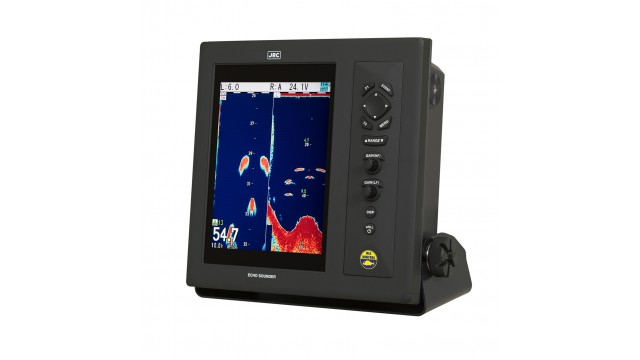
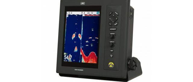
JLN-720

The JLN-720 satellite log provides accurate ship speed and distance right with your fingertip operation. Regardless of weather conditions, the system is capable of providing accurate speed up to an amazing 0.02kn or 0.2% all over the world using JRC’s proven GPS compass technology. On the bridge the system is operated on a color LCD display with touch panel, providing clear and straightforward information. The processor is built into the antenna which eliminates alignment between antenna and processor, therefore contributing to an easy setup with less error and significantly reduced installation time. This concept also reduces the installation costs as only a single cable is used between antenna and processor unit. Should something interfere with the coverage, the proven antenna design incorporates a layer of air that reduces possible blind spots, allowing for a more precise speed than conventional systems.

2020-06-11T18:45:07-03:0022/04/2020|

JLN-740

The JLN-741A series is a single axis water SDME compliant with the IMO MSC.96 (72) standard, required on all internationally voyaging ships exceeding 300 GT. Boasting never-before-seen accuracy for speed measurement, the JLN-740 is also installed with our company’s proprietary bubble detection function, which informs you when measurement accuracy is impaired due to air bubble contact. The JLN-741A series utilizes digital signal processing, which, coupled with optimizations to existing speed measurement waveforms and the reliability of ship bottom mounting, has resulted in water speed measurement with accuracy up to 0.03kn or 0.3% in all models (measured at fixed speeds). That accuracy of information allows for highly fuel-efficient speeds, which means faster voyages with less waste. Along with improved speed measurements, the series also has greatly improved ship speed tracking, relaying all the information you need for precise navigation during berthing. A long-unsolvable problem with doppler-based water speed measuring systems was reduced accuracy from bubbles making contact with the measuring device on the bottom of the vessel. The JLN-741N series detects when bubbles contact the transducer, and using roprietary technology from JRC alerts you of reduced measuring accuracy via the display. Confirming the source of the issue typically requires visually examining the device on the bottom of the ship. However, onboard air bubble detection allows you to skip unnecessary preventive maintenance.

2020-06-11T18:39:33-03:0022/04/2020|

JHS-183

The JHS-183 AIS is a ship borne system capable of regularly broadcasting own ship’s unique information and continually receiving and displaying information broadcast from other vessels. The AIS can "see around corners", allowing avoidance of dangers before visual contact has been established. All ship’s information including static and voyage related data such as the ship’s name and cargo, as well as its dynamic navigational information, i.e., position, course, and speed can be transmitted and received. The JHS-183 is an important piece of navigation equipment onboard for collision avoidance and maneuvering. The information broadcast from other ships displayed on the AIS, together with the geographical information shown on the radar or ECDIS provides highly important data for strategic decisions and for prompt contact with other ships. The JHS-183 is able to display up to 200 AIS targets and the excellent on-screen menus will greatly shorten most users' learning period.

2020-06-09T01:08:10-03:0022/04/2020|

A200

The em-trak A200 AIS Class A sets new standards of performance, functionality and reliability. As a single, fully integrated Class A transceiver, the A200 is easily installed and configured with dual NMEA2000 and NMEA0183 connectivity allowing plug & play integration with other bridge systems. The hi-resolution full-colour display delivers a range of powerful functionality, including full CMAP ENC charting, multiple text and graphic display modes, AIS target management, proximity alerts, MOB/SAR alert and tracking and much more. Despite its unmatched performance and functionality, the A200 is ruggedized being completely water, weather and vibration proof such that it will operate reliably for years without maintenance in even the most extreme marine environments. The A200 is engineered and built for commercial users who rely on their AIS Class A day after day for their safety, security and operational efficiency

2020-06-09T01:01:44-03:0022/04/2020|

JLR-7500/7800

The JLR-7500/JLR-7800 (D)GPS navigator will locate your position accurately and gives you a wide range of possibilities. Integrated with the latest technologies. That will enhance your operational performance. Of the new display modes is the 3D highway, which allows you to intuitively view the location of the next waypoint. This 3D guidance is particularly valuable to follow a real-time chain of waypoints along a planned route. The new (D)GPS navigator allows you to plan long distance routes highly effective. It is possible to set Rhumb lines (RL) for short legs, while Great Circle (GC) can be set for the long distance legs. All possible within the same route. Simply make your selection for each leg to reach your destination effortlessly. All information is displayed on a highly visible 5.7-inch LCD display, featuring added sharpness and contrast compared to the previous version. Many display modes are readily available and selectable from the menu, such as navigation, CDI, highway, track plotting and service and information screens. The display has four dim modes, allowing adjusting at your own convenience.

2020-06-12T09:36:08-03:0022/04/2020|

JLR-7600/7900

The JLR-7600 GPS navigator will locate your position fast and with high accuracy, keeping the unit compact and easy to install. Up to 1,000 waypoints can be stored in the internal memory. All waypoints can be named and renamed up to sixteen characters. You can make 20 routes with 50 waypoints per route, which can be entered randomly, and there's room for 2,000 points for ships' track and up to 1,000 for events and marks. The JRC MID incorporates many display modes readily available on a highly visible 4.5-inch LCD display. Besides the display being fully dimmable and having backlit keys, it features dual LED backlight (white and orange), making it easy to operate in various light settings on the bridge. Multiple display modes are available from the menu with main data displayed in large characters for easy reading. You can easily switch at your own convenience, particularly useful when a situation requires specific information.

2020-06-12T09:39:19-03:0022/04/2020|

JLR-8400

The compact JLR-8400 GPS navigator is compatible with Multi GNSS and will provide accurate position data even in Arctic area, without SBAS and beacon. The newly designed multi-GNSS sensor is capable of receiving data from GPS as well as GLONASS, QZSS or BeiDou at the same time, allowing for a highly accurate positioning without beacon and SBAS. The sensor can increase the accuracy of your position by receiving SBAS correction data. The JLR-8400 is very compact and can virtually be mounted anywhere using the desktop flush mount system. The base of the sensor is designed for an easy installation, either on a pole or on a suitable bracket. The base also includes a slot allowing for easy cable management.

2020-06-11T20:12:21-03:0022/04/2020|

JLR-8600

The new JLR-8600 GPS navigator combined with our trusted 6.5-inch touch display will locate your position with high accuracy utilizing our newly designed antenna, providing you with the comfort of an intuitive operational approach. The newly designed multi-GNSS sensor is capable of receiving data from GPS as well as GLONASS or BeiDou at the same time, allowing for a highly accurate positioning, regardless of the weather conditions. The sensor can increase the accuracy of your position by receiving correction data SBAS satellites. The display is very compact and can virtually be mounted anywhere using our snap on flush mount system. The base of the sensor is designed for an easy installation, either on a pole or on an extension mast. The base also includes a slot allowing for easy cable management. Connecting everything together allows for a high reliability installation approach with redundancy of sensors, power supply and processor units.

2020-06-11T20:09:31-03:0022/04/2020|

JLR-21

The JLR-21 GPS compass continues the success of its predecessor, reaching a new level of performance and stability with many new features and enhancements. This system is also known as a 3D Dynamic Sensor™, which besides giving heading information, is designed to provide highly accurate information of the ships movement in all axis. The JLR-21 has heave functionality built-in as standard. In rough ocean conditions (with high waves), the GPS compass can correct up and down (attitude), movement. JLR-21 supports Speed Over Ground (SOG) and Course Over Ground (COG). The position, SOG and COG are updated every 200 milliseconds (which is 5 times faster than previous model JLR-20), delivering high accuracy.

2020-06-11T20:15:55-03:0022/04/2020|

JLR-31

The JLR-31 GPS compass continues the success of its predecessor, reaching a new level of performance and stability with many new features and enhancements. This system is also known as a 3D Dynamic Sensor™, which besides giving heading information, is designed to provide highly accurate information of the ships movement in all axis. The JLR-31 has heave functionality built-in as standard. In rough ocean conditions (with high waves), the GPS compass can correct up and down (attitude), movement. JLR-31 supports Speed Over Ground (SOG) and Course Over Ground (COG). The position, SOG and COG are updated every 200 milliseconds (which is 5 times faster than previous model JLR-20), delivering high accuracy.

2020-06-11T20:15:59-03:0022/04/2020|