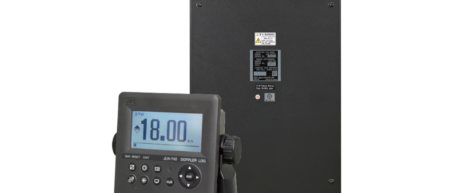
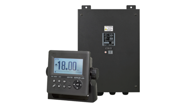
JLN-740

The JLN-741A series is a single axis water SDME compliant with the IMO MSC.96 (72) standard, required on all internationally voyaging ships exceeding 300 GT. Boasting never-before-seen accuracy for speed measurement, the JLN-740 is also installed with our company’s proprietary bubble detection function, which informs you when measurement accuracy is impaired due to air bubble contact. The JLN-741A series utilizes digital signal processing, which, coupled with optimizations to existing speed measurement waveforms and the reliability of ship bottom mounting, has resulted in water speed measurement with accuracy up to 0.03kn or 0.3% in all models (measured at fixed speeds). That accuracy of information allows for highly fuel-efficient speeds, which means faster voyages with less waste. Along with improved speed measurements, the series also has greatly improved ship speed tracking, relaying all the information you need for precise navigation during berthing. A long-unsolvable problem with doppler-based water speed measuring systems was reduced accuracy from bubbles making contact with the measuring device on the bottom of the vessel. The JLN-741N series detects when bubbles contact the transducer, and using roprietary technology from JRC alerts you of reduced measuring accuracy via the display. Confirming the source of the issue typically requires visually examining the device on the bottom of the ship. However, onboard air bubble detection allows you to skip unnecessary preventive maintenance.

2020-06-11T18:39:33-03:0022/04/2020|

JLN-741

The JLN-741N is a cost-effective doppler speed log with a 4.5-inch display with the main data displayed in large characters of easy reading. In addition that the display is fully dimmable and has backlit keys, it features dual LED backlight (white and orange) making it easy to operate in various light settings on the bridge. The JLN-741N is a single axis water SDME compliant with the IMO MSC.96 (72) standard, required on all internationally voyaging ships exceeding 300 GT. Boasting never-before-seen accuracy for speed measurement, the JLN-741N is also installed with our company’s proprietary bubble detection function, which informs you when measurement accuracy is impaired due to air bubble contact. A long-unsolvable problem with doppler-based water speed measuring systems was reduced accuracy from bubbles making contact with the measuring device on the bottom of the vessel. The JLN-741N series detects when bubbles contact the transducer, and using roprietary technology from JRC alerts you of reduced measuring accuracy via the display. Confirming the source of the issue typically requires visually examining the device on the bottom of the ship. However, onboard air bubble detection allows you to skip unnecessary preventive maintenance.

2020-06-11T18:38:15-03:0022/04/2020|

EML-500

A preamplifier is built into the sensor for stable and long-distance transmission (max.300m long) of the current signal. The EML500 can receive a backup signal(NMEA-0183) from external speed sensors such as a GPS receiver. A dual-axis sensor (optional) measures a ship's transverse speed as well as its longitudinal speed.

2020-06-12T01:31:57-03:0022/04/2020|

EML-50

Easy to read analog bar graphics and digital indicators accurately read out the ship's speed on the display. An electromagnetic counter displays the distance traveled, and the counter is resettable. A preamplifier is built into the sensor for stable and long-distance transmission (max. 300m long) of the current signal.

2020-04-22T16:58:59-03:0022/04/2020|

JLR-31

The JLR-31 GPS compass continues the success of its predecessor, reaching a new level of performance and stability with many new features and enhancements. This system is also known as a 3D Dynamic Sensor™, which besides giving heading information, is designed to provide highly accurate information of the ships movement in all axis. The JLR-31 has heave functionality built-in as standard. In rough ocean conditions (with high waves), the GPS compass can correct up and down (attitude), movement. JLR-31 supports Speed Over Ground (SOG) and Course Over Ground (COG). The position, SOG and COG are updated every 200 milliseconds (which is 5 times faster than previous model JLR-20), delivering high accuracy.

2020-06-11T20:15:59-03:0022/04/2020|

JFC-130

JRC’s JFC-130 echo sounder incorporates a 10.4” high definition color LCD display. The innovative display modes allow you to select and view four kinds of 16 color gradations and background colors. Day and night mode is also available to support particular daytime operations. Keys and controls on the operation panel are minimized. Sensitivity, clutter rejection and STC are finely adjustable depending upon sea areas, seasons and fishing methods. Three types of fishing ground or fish species can be displayed and stored. Once they are on-screen, any type of fishing ground of fish species can be set and reset to another type by simply pushing the CUSTOM button. The adoption of a zero-line function, the new transducer makes the line finer. The high-speed emission of 600 (JFC-130) and 300 (JFC-130HP) pulses or more per minute enables small fish in the surface water to be clearly detected. The bottom enlargement display in 16 color gradations discriminates bottom fish from the sea bottom distinctly.

2020-06-12T12:07:36-03:0022/04/2020|

NW6000 Netwave

Netwave’s NW-6000 VDR system architecture is unique in the fact that the various components throughout the ship are interconnected by means of one single Ethernet cable, both Power and Data are provided over this very same single cable, eliminating the need for extensive and complex, and therefore costly, cabling requirements. Compared to other VDR systems, cabling costs are typically reduced by 50%! The standard VDR and (S)VDR systems consist of the following components: NetWave NW6000 Core Unit, NW6860-1000 Fixed capsule, NW-6680 Float free capsule, NW-6010 Bridge control Unit, NW-6020 PoE Microphones, and others.

2020-06-10T14:35:09-03:0022/04/2020|

JHS-183

The JHS-183 AIS is a ship borne system capable of regularly broadcasting own ship’s unique information and continually receiving and displaying information broadcast from other vessels. The AIS can "see around corners", allowing avoidance of dangers before visual contact has been established. All ship’s information including static and voyage related data such as the ship’s name and cargo, as well as its dynamic navigational information, i.e., position, course, and speed can be transmitted and received. The JHS-183 is an important piece of navigation equipment onboard for collision avoidance and maneuvering. The information broadcast from other ships displayed on the AIS, together with the geographical information shown on the radar or ECDIS provides highly important data for strategic decisions and for prompt contact with other ships. The JHS-183 is able to display up to 200 AIS targets and the excellent on-screen menus will greatly shorten most users' learning period.

2020-06-09T01:08:10-03:0022/04/2020|

A200

The em-trak A200 AIS Class A sets new standards of performance, functionality and reliability. As a single, fully integrated Class A transceiver, the A200 is easily installed and configured with dual NMEA2000 and NMEA0183 connectivity allowing plug & play integration with other bridge systems. The hi-resolution full-colour display delivers a range of powerful functionality, including full CMAP ENC charting, multiple text and graphic display modes, AIS target management, proximity alerts, MOB/SAR alert and tracking and much more. Despite its unmatched performance and functionality, the A200 is ruggedized being completely water, weather and vibration proof such that it will operate reliably for years without maintenance in even the most extreme marine environments. The A200 is engineered and built for commercial users who rely on their AIS Class A day after day for their safety, security and operational efficiency

2020-06-09T01:01:44-03:0022/04/2020|

JLR-7500/7800

The JLR-7500/JLR-7800 (D)GPS navigator will locate your position accurately and gives you a wide range of possibilities. Integrated with the latest technologies. That will enhance your operational performance. Of the new display modes is the 3D highway, which allows you to intuitively view the location of the next waypoint. This 3D guidance is particularly valuable to follow a real-time chain of waypoints along a planned route. The new (D)GPS navigator allows you to plan long distance routes highly effective. It is possible to set Rhumb lines (RL) for short legs, while Great Circle (GC) can be set for the long distance legs. All possible within the same route. Simply make your selection for each leg to reach your destination effortlessly. All information is displayed on a highly visible 5.7-inch LCD display, featuring added sharpness and contrast compared to the previous version. Many display modes are readily available and selectable from the menu, such as navigation, CDI, highway, track plotting and service and information screens. The display has four dim modes, allowing adjusting at your own convenience.

2020-06-12T09:36:08-03:0022/04/2020|